
Executive Development Programme in Creating Spatial Presentations with Data Visualization Tools
Master spatial data visualization to transform complex datasets into compelling, actionable insights for superior executive decision-making.
Executive Development Programme in Creating Spatial Presentations with Data Visualization Tools
Programme Summary
The Executive Development Programme in Creating Spatial Presentations with Data Visualization Tools equips senior leaders and urban planners with the technical proficiency required to transform complex geospatial datasets into compelling visual narratives. This intensive curriculum targets executives in real estate, logistics, and public policy who must interpret location-based intelligence to drive strategic decision-making. Participants engage with industry-standard software platforms to map demographic trends, environmental factors, and infrastructure developments across diverse geographical scales. The programme bridges the gap between raw spatial data and executive-level communication, ensuring that stakeholders receive clear, actionable insights rather than overwhelming statistical tables.
Learners master the integration of GIS technologies with advanced visualization frameworks to produce high-impact dashboards and interactive maps. The syllabus covers critical techniques for layering multiple data sources, optimizing visual hierarchy, and selecting appropriate colour schemes to enhance data readability. Participants learn to identify spatial patterns and anomalies that traditional reporting methods often obscure, thereby refining their analytical precision. The course emphasizes rigorous data validation processes to ensure that all visual outputs maintain statistical integrity and adhere to professional ethical standards. Graduates emerge capable of designing presentations that accurately reflect spatial realities while persuading diverse audiences.
Completion of this programme significantly enhances a leader’s ability to influence investment strategies and operational planning through evidence-based spatial storytelling. Organizations benefit from reduced decision latency as executives rapidly interpret location-specific risks and opportunities. Professionals who apply these skills often secure leadership roles in urban development, supply chain optimization, and geographic information services. The certification signals a mastery of digital spatial literacy,
Learning Outcomes
This rigorous Executive Development Programme equips senior leaders with the strategic capability to transform complex datasets into compelling spatial narratives. In an era defined by big data, the ability to visualise geographic information is no longer a niche technical skill but a critical leadership competency. Participants will master industry-standard tools, including ArcGIS and Tableau, to create dynamic maps that reveal hidden patterns, drive operational efficiency, and support evidence-based decision-making.
The curriculum bridges the gap between raw data and strategic insight. Key modules cover geospatial analytics, the principles of effective cartographic design, and the integration of real-time data streams into interactive dashboards. Learners will engage in hands-on workshops that challenge them to solve real-world business problems, from optimising supply chain logistics to identifying new market opportunities through demographic clustering. By the end of the course, delegates will possess a robust portfolio of spatial presentations that communicate intricate findings with clarity and impact.
Graduates emerge ready to lead data-driven initiatives across diverse sectors. They will apply these skills to streamline urban planning projects, enhance retail site selection strategies, and improve emergency response coordination. The programme fosters a mindset of spatial thinking, enabling executives to ask the right questions and interpret location-based intelligence effectively.
Career opportunities for alumni are extensive and high-impact. Participants often advance into roles such as Chief Data Officer, Head of Business Intelligence, or Strategic Planning Director. Others leverage their expertise to consult for multinational corporations, helping them navigate the complexities of global expansion. This programme does not
Programme Features
Industry-Aligned Curriculum
Developed with industry leaders for job-ready skills
Globally Recognised Certificate
Recognised by employers across 180+ countries
Flexible Online Learning
Study at your own pace with lifetime access
Instant Access
Start learning immediately, no application process
Constantly Updated Content
Latest industry trends and best practices
Career Advancement
87% report measurable career progression within 6 months
Course Modules
- Spatial Data Fundamentals: Introduces geographic information systems and spatial data structures.: Data Preparation for Mapping: Covers cleaning, transforming, and structuring datasets for visualization.
- Visual Encoding Principles: Explores color theory, scale, and symbolization for effective communication.: Interactive Dashboard Design: Teaches the creation of dynamic, user-driven spatial interfaces.
- Advanced Analytics Integration: Demonstrates linking statistical models with geographic layers.: Strategic Storytelling with Maps: Focuses on crafting compelling narratives using spatial evidence.
What's Included in This Programme
Here is what you get when you enrol with LSBR London
Programme Facts
Audience: Senior executives requiring advanced spatial data communication skills.
Prerequisites: Basic proficiency in standard data visualisation software platforms.
Outcomes: Mastery of geospatial storytelling for strategic decision-making processes.
Ready to advance your career?
Join thousands of professionals who have transformed their careers with LSBR London. Enrol today and start learning immediately.
Why Study This Programme
The Executive Development Programme in Creating Spatial Presentations with Data Visualization Tools offers a distinct competitive advantage for senior professionals navigating the complexities of modern data-driven decision-making. This curriculum bridges the critical gap between raw geospatial data and strategic insight, ensuring that executives can communicate complex findings with clarity and precision.
Enhanced Strategic Communication: Participants master the art of translating intricate spatial datasets into compelling visual narratives. This capability allows leaders to articulate geographic trends and market dynamics effectively to stakeholders, thereby accelerating consensus and driving informed strategic choices without overwhelming audiences with technical jargon.
Advanced Technical Proficiency: The programme provides rigorous training in industry-leading visualization platforms. By engaging with these tools directly, professionals acquire the technical confidence to manipulate large-scale spatial data independently, reducing reliance on IT departments and enabling real-time analysis during critical boardroom discussions or client presentations.
Improved Decision-Making Agility: Understanding spatial relationships within data empowers executives to identify hidden patterns and regional opportunities. This skill set fosters a more nuanced approach to risk assessment and resource allocation, leading to more robust business strategies that are grounded in empirical evidence rather than intuition alone.
Career Differentiation: In an increasingly competitive job market, possessing specialized expertise in spatial data visualization distinguishes candidates from their peers. This unique skill combination signals a forward-thinking mindset and a commitment to leveraging advanced analytics, making professionals highly attractive to organisations seeking innovative leaders capable of harnessing the full potential of geographic information systems.
"This programme gave me the confidence and credentials to secure a senior role. Highly recommend LSBR London."
— Sarah M., United Kingdom
Course Brochure
Download our comprehensive course brochure with all details
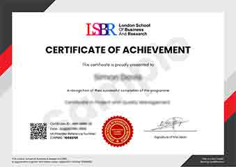
Sample Certificate
Preview the certificate you'll receive upon successful completion of this program.
Get Course Info
Receive the full course guide, pricing details, and enrolment instructions directly in your inbox.
Check your inbox!
Course details have been sent to your email.
Get Your Employer to Sponsor This Programme
Many employers offer professional development budgets. We make it easy for your company to invest in your growth with corporate invoicing and bulk enrolment options.
Email Template for Your Manager
Dear [Manager's Name],
I would like to request sponsorship for the Executive Development Programme in Creating Spatial Presentations with Data Visualization Tools programme offered by LSBR London - Executive Education.
The programme costs $199 (one-time) and can be completed in 3-4 weeks alongside my regular duties.
Key benefits to our team:
- Immediately applicable skills
- Globally recognised certificate
- Corporate invoice available
Best regards,
[Your Name]
What Our Students Say
Hear from our students about their experience with the Executive Development Programme in Creating Spatial Presentations with Data Visualization Tools at LSBR London - Executive Education.
Oliver Davies
United Kingdom"The course material provided a robust foundation in translating complex spatial data into compelling visual narratives using industry-standard tools. I gained immediate practical skills in designing intuitive maps and dashboards that significantly enhance decision-making processes in my professional projects."
James Thompson
United Kingdom"Mastering spatial data visualization has transformed how I communicate complex urban planning insights to stakeholders, making my presentations far more persuasive and impactful. This specialized skill set has directly accelerated my career progression, positioning me as a key decision-maker in projects that require clear, data-driven spatial storytelling."
Ryan MacLeod
Canada"The logical progression of the modules allowed me to seamlessly integrate complex spatial data into compelling visual narratives. This structured approach significantly enhanced my ability to communicate technical insights effectively to non-technical stakeholders."
Your Certification Journey
Four simple steps from enrolment to your globally recognised certificate
Enrol Online
Complete your enrolment in under 2 minutes with secure checkout
Start Learning
Get instant access to all course materials and start at your own pace
Complete Modules
Work through the curriculum with expert support available throughout
Get Certified
Receive your LSBR London certificate recognised across 180+ countries
LSBR London by the Numbers
Join a global community of professionals advancing their careers
Students Enrolled
Countries Represented
Average Rating
Career Progression