
Professional Certificate in Geometric Database Management for GIS
Develop comprehensive geometric database management for gis expertise through structured learning. Build confidence in practical applications.
Professional Certificate in Geometric Database Management for GIS
Programme Summary
This rigorous professional certificate equips spatial analysts and database administrators with advanced expertise in managing complex geometric data structures within Geographic Information Systems. The curriculum targets IT professionals and urban planners seeking to optimise large-scale spatial repositories for enterprise-level applications. Participants engage with industry-standard relational databases to master the storage, indexing, and retrieval of multidimensional geometric entities. The programme addresses critical challenges in data integrity and performance tuning for high-volume geospatial datasets.
Learners acquire profound technical proficiency in SQL extensions for spatial querying and the implementation of efficient spatial indexing mechanisms. Students master the normalisation of geometric features to ensure data consistency across distributed systems. The course emphasises the design of robust schema architectures that support rapid spatial joins and proximity analyses. Participants develop the ability to troubleshoot complex geometric topology errors and implement automated validation routines. These competencies ensure precise handling of vector and raster data within modern GIS environments.
Graduates emerge as highly sought-after specialists capable of leading spatial data infrastructure projects in government and private sectors. This qualification significantly enhances employability in roles requiring advanced database optimisation for location-intelligence platforms. Professionals leverage these skills to drive operational efficiency and support data-driven decision-making in logistics and urban development. The certificate validates a practitioner’s ability to align technical database solutions with strategic organisational objectives. Alumni frequently secure senior positions in geospatial engineering and data management teams.
Learning Outcomes
This rigorous Professional Certificate equips spatial analysts and data engineers with the advanced technical competencies required to manage complex geometric datasets within Geographic Information Systems. As urban planning, logistics, and environmental monitoring increasingly rely on precise spatial intelligence, the demand for specialists who can optimise geometric database performance has never been greater. This programme bridges the critical gap between theoretical spatial mathematics and practical database administration, ensuring participants can handle large-scale geospatial operations with efficiency and accuracy.
The curriculum delves deeply into the intricacies of spatial indexing mechanisms, such as R-trees and Quad-trees, which are essential for accelerating query performance in massive datasets. Students will master the implementation of spatial SQL dialects, focusing on PostGIS and Oracle Spatial, while exploring advanced topics including topology validation, coordinate reference system transformations, and the integration of real-time streaming data. Through hands-on workshops, learners will construct robust spatial data warehouses capable of supporting high-frequency updates and complex analytical queries.
Graduates emerge with the ability to design scalable architectures that support critical decision-making processes across diverse sectors. They will apply these skills to streamline supply chain logistics, enhance precision agriculture models, and improve urban infrastructure management. By mastering the optimisation of spatial joins and spatial aggregations, professionals can significantly reduce computational latency, thereby enabling real-time analytics in dynamic environments.
Career prospects for certificate holders are extensive and lucrative. Alumni frequently secure roles as Geospatial Database Administrators, Spatial Data Architects, or GIS Solutions Engineers within leading technology firms, government agencies
Programme Features
Industry-Aligned Curriculum
Developed with industry leaders for job-ready skills
Globally Recognised Certificate
Recognised by employers across 180+ countries
Flexible Online Learning
Study at your own pace with lifetime access
Instant Access
Start learning immediately, no application process
Constantly Updated Content
Latest industry trends and best practices
Career Advancement
87% report measurable career progression within 6 months
Course Modules
- Spatial Data Fundamentals: Introduces the core principles of geometric data structures and coordinate reference systems.: Geometric Database Architecture: Examines the design and implementation of spatial databases using industry-standard engines.
- Advanced Spatial Querying: Focuses on writing efficient SQL queries for complex geometric operations and spatial relationships.: Indexing and Performance Optimization: Explores techniques for indexing spatial data to ensure fast retrieval and processing speeds.
- Geometric Data Modeling: Covers strategies for modeling real-world geographic features within a relational database framework.: Integration with GIS Applications: Demonstrates how to connect geometric databases with desktop and web-based GIS software.
What's Included in This Programme
Here is what you get when you enrol with LSBR London
Programme Facts
Audience: GIS analysts seeking advanced spatial data competency.
Prereq: Foundational knowledge of database systems and GIS principles.
Out: Mastery of geometric indexing and spatial query optimisation techniques.
This certificate equips professionals with rigorous skills in managing complex spatial datasets. Graduates gain the expertise required to design efficient geometric databases. The curriculum emphasises practical application within enterprise-level geographic information systems. Participants emerge prepared to lead data architecture initiatives. This qualification enhances career prospects in geospatial technology sectors.
Ready to advance your career?
Join thousands of professionals who have transformed their careers with LSBR London. Enrol today and start learning immediately.
Why Study This Programme
Pursuing a Professional Certificate in Geometric Database Management for GIS represents a strategic investment in long-term career resilience. The contemporary geospatial landscape demands more than mere map creation; it requires sophisticated data architecture. This programme addresses that critical gap by equipping professionals with advanced technical competencies that are increasingly scarce in the market.
It cultivates mastery over spatial indexing and query optimisation, enabling practitioners to handle massive datasets with unprecedented speed and precision. This technical proficiency directly translates to improved operational efficiency within urban planning and logistics sectors, where real-time data processing is paramount.
The curriculum emphasises robust data integrity and topological consistency, skills essential for mitigating risks in infrastructure management. Professionals gain the ability to design error-resistant databases, thereby reducing costly project delays and enhancing the reliability of spatial decision-making processes across multinational organisations.
By bridging the divide between traditional GIS operations and modern database administration, this certification positions candidates for hybrid roles that command higher salaries. It demonstrates to employers a unique capability to manage complex geometric structures within relational and non-relational databases, a versatile skill set highly valued in the growing fintech and smart city industries.
Participants develop a deep understanding of standardised spatial data models, ensuring interoperability across diverse software platforms. This adaptability allows professionals to lead digital transformation initiatives, facilitating seamless data exchange and fostering innovation in cross-functional teams.
Engaging with this rigorous training ensures that individuals remain at the forefront of geospatial technology,
"This programme gave me the confidence and credentials to secure a senior role. Highly recommend LSBR London."
— Sarah M., United Kingdom
Course Brochure
Download our comprehensive course brochure with all details
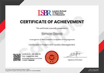
Sample Certificate
Preview the certificate you'll receive upon successful completion of this program.
Get Course Info
Receive the full course guide, pricing details, and enrolment instructions directly in your inbox.
Check your inbox!
Course details have been sent to your email.
Get Your Employer to Sponsor This Programme
Many employers offer professional development budgets. We make it easy for your company to invest in your growth with corporate invoicing and bulk enrolment options.
Email Template for Your Manager
Dear [Manager's Name],
I would like to request sponsorship for the Professional Certificate in Geometric Database Management for GIS programme offered by LSBR London - Executive Education.
The programme costs $149 (one-time) and can be completed in 3-4 weeks alongside my regular duties.
Key benefits to our team:
- Immediately applicable skills
- Globally recognised certificate
- Corporate invoice available
Best regards,
[Your Name]
What Our Students Say
Hear from our students about their experience with the Professional Certificate in Geometric Database Management for GIS at LSBR London - Executive Education.
Charlotte Williams
United Kingdom"The course material was exceptionally clear and up‑to‑date, walking me through advanced spatial indexing, topology rules, and data normalization techniques that are directly applicable to real GIS projects. I now feel confident building and optimizing geometric databases, which has already opened up new opportunities in spatial analysis and data engineering roles."
Kavya Reddy
India"The certificate gave me a solid grasp of spatial indexing, topology rules, and real‑time data integration, which I’ve already applied to streamline our city’s asset management system. Since completing the program, I’ve been promoted to lead GIS analyst and am now handling enterprise‑level database projects that directly impact planning decisions."
Jack Thompson
Australia"The course’s logical progression—from foundational spatial concepts to advanced indexing techniques—made complex topics easy to follow, and each module built clearly on the previous one. The comprehensive coverage of real-world GIS database scenarios gave me practical tools I can apply immediately, boosting my confidence and readiness for professional projects."
Your Certification Journey
Four simple steps from enrolment to your globally recognised certificate
Enrol Online
Complete your enrolment in under 2 minutes with secure checkout
Start Learning
Get instant access to all course materials and start at your own pace
Complete Modules
Work through the curriculum with expert support available throughout
Get Certified
Receive your LSBR London certificate recognised across 180+ countries
LSBR London by the Numbers
Join a global community of professionals advancing their careers
Students Enrolled
Countries Represented
Average Rating
Career Progression