
Professional Certificate in Geospatial Tree Risk Assessment
Elevate your skills with a Professional Certificate in Geospatial Tree Risk Assessment, enhancing your ability to safely manage urban forestry and reduce liability.
Professional Certificate in Geospatial Tree Risk Assessment
Programme Overview
The Professional Certificate in Geospatial Tree Risk Assessment is a comprehensive program designed for arborists, urban foresters, landscape architects, and land managers. This program equips participants with advanced geospatial techniques and risk assessment strategies to evaluate and manage tree health and safety in various environments, including urban, suburban, and natural settings. Learners will gain proficiency in using geographic information systems (GIS) software, remote sensing technologies, and risk assessment models to identify and mitigate potential hazards associated with trees and their surroundings.
Participants will develop key skills in data collection, analysis, and interpretation using geospatial tools, allowing them to make informed decisions about tree health and safety. They will learn to conduct comprehensive risk assessments, integrate various data sources, and create detailed risk maps that inform management strategies. Additionally, the program includes hands-on training in fieldwork, risk mitigation techniques, and the application of best practices in tree care and public safety.
By completing this program, learners will enhance their professional capabilities and increase their marketability in the field of urban forestry and arboriculture. The knowledge and skills acquired will enable them to conduct sophisticated geospatial analyses, effectively communicate risk assessments to stakeholders, and implement sustainable tree management practices. Graduates will be well-prepared to meet the challenges of ensuring public safety and environmental sustainability in the face of increasing urbanization and climate change.
What You'll Learn
The Professional Certificate in Geospatial Tree Risk Assessment equips participants with the advanced skills necessary to evaluate tree health and structural integrity using cutting-edge geospatial technologies. This program is ideal for arborists, environmental consultants, and urban foresters looking to enhance their professional capabilities in risk management and environmental sustainability.
Key topics include the principles of tree biology, geospatial data analysis, and the integration of GIS (Geographic Information Systems) for accurate tree risk assessment. Participants will learn to interpret aerial imagery, conduct on-site assessments, and use specialized software to model tree stability and predict potential hazards. The curriculum also emphasizes the importance of communication and reporting in the field of tree risk assessment.
Graduates will be able to apply these skills in various settings, from urban park management and landscape design to real estate development and public safety planning. They will be well-prepared to identify and mitigate risks associated with trees in hazardous locations, ensuring the safety of communities and property. This certification opens doors to advanced career opportunities in arboriculture, environmental consulting, and urban planning, as well as potential leadership roles in organizations focused on environmental stewardship and sustainability.
Programme Highlights
Industry-Aligned Curriculum
Developed with industry leaders for job-ready skills
Globally Recognised Certificate
Recognised by employers across 180+ countries
Flexible Online Learning
Study at your own pace with lifetime access
Instant Access
Start learning immediately, no application process
Constantly Updated Content
Latest industry trends and best practices
Career Advancement
87% report measurable career progression within 6 months
Topics Covered
- Foundational Concepts: Covers the core principles and key terminology.: Risk Assessment Techniques: Introduces methods for evaluating tree risks.
- Tree Biology and Health: Focuses on understanding tree anatomy and health indicators.: Environmental Factors: Analyzes how environmental conditions affect tree stability.
- Case Studies: Examines real-world scenarios and their management.: Legal and Ethical Considerations: Discusses legal frameworks and ethical practices in tree risk assessment.
Everything Included in Your Enrolment
Here is what you get when you enrol with LSBR London
Key Facts
Audience: Arborists, Landscapers, Foresters
Prerequisites: Basic tree care knowledge
Outcomes: Competent in risk assessment techniques, certified evaluator
Ready to advance your career?
Join thousands of professionals who have transformed their careers with LSBR London. Enrol today and start learning immediately.
Why This Course
Enhance Competency and Credibility: Achieving a Professional Certificate in Geospatial Tree Risk Assessment demonstrates a deep understanding of tree health and risk assessment techniques. This certification equips professionals with advanced skills in identifying and mitigating risks associated with trees, making them more credible in the eyes of clients and employers. For instance, arborists who hold such a certificate can accurately assess the structural integrity of trees and advise on necessary actions, such as pruning or removal, to prevent potential hazards.
Expand Career Opportunities: The demand for geospatial tree risk assessment is increasing as more communities and organizations recognize the importance of maintaining tree health for safety and environmental reasons. Professionals with this certification can pursue roles in urban forestry, property management, landscape architecture, and environmental consulting. For example, arborists can offer specialized services to assess tree risks for commercial properties, parks, or public spaces, thereby broadening their career scope.
Improve Decision-Making: The certificate provides comprehensive training in using geospatial technologies like GIS (Geographic Information Systems) to analyze tree data. This skillset enhances professionals' ability to make informed decisions about tree care and risk management. For instance, foresters can utilize geospatial data to prioritize tree maintenance efforts, ensuring resources are allocated effectively and efficiently.
"This programme gave me the confidence and credentials to secure a senior role. Highly recommend LSBR London."
— Sarah M., United Kingdom
Course Brochure
Download our comprehensive course brochure with all details
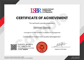
Sample Certificate
Preview the certificate you'll receive upon successful completion of this program.
Get Course Info
Receive the full course guide, pricing details, and enrolment instructions directly in your inbox.
Check your inbox!
Course details have been sent to your email.
Get Your Employer to Sponsor This Programme
Many employers offer professional development budgets. We make it easy for your company to invest in your growth with corporate invoicing and bulk enrolment options.
Email Template for Your Manager
Dear [Manager's Name],
I would like to request sponsorship for the Professional Certificate in Geospatial Tree Risk Assessment programme offered by LSBR London - Executive Education.
The programme costs $149 (one-time) and can be completed in 3-4 weeks alongside my regular duties.
Key benefits to our team:
- Immediately applicable skills
- Globally recognised certificate
- Corporate invoice available
Best regards,
[Your Name]
What People Say About Us
Hear from our students about their experience with the Professional Certificate in Geospatial Tree Risk Assessment at LSBR London - Executive Education.
Charlotte Williams
United Kingdom"The course content is incredibly thorough and well-organized, providing a solid foundation in assessing tree risks from a professional perspective. Gaining hands-on experience through real-world case studies has significantly enhanced my ability to evaluate and manage tree risks effectively, which is incredibly valuable for my career in landscape management."
Mei Ling Wong
Singapore"This course has been incredibly valuable in enhancing my ability to assess tree risks professionally. It has not only provided me with a robust set of skills but also opened up new career opportunities in the field of urban forestry and landscape management."
Kavya Reddy
India"The course structure is meticulously organized, providing a clear path from foundational concepts to advanced techniques in geospatial tree risk assessment, which has significantly enhanced my ability to apply these skills in real-world scenarios. It offers a wealth of comprehensive content that bridges theory with practical applications, fostering professional growth in the field."
Your Path to Certification
Four simple steps from enrolment to your globally recognised certificate
Enrol Online
Complete your enrolment in under 2 minutes with secure checkout
Start Learning
Get instant access to all course materials and start at your own pace
Complete Modules
Work through the curriculum with expert support available throughout
Get Certified
Receive your LSBR London certificate recognised across 180+ countries
LSBR London by the Numbers
Join a global community of professionals advancing their careers
Students Enrolled
Countries Represented
Average Rating
Career Progression
Join Thousands Who Transformed Their Careers
Our graduates consistently report measurable career growth and professional advancement after completing their programmes.
Still deciding?
Join 23,000+ professionals who advanced their careers. Enroll today and start learning immediately.
Enroll NowSecure payment • Instant access • Certificate included