
Professional Certificate in Remote Sensing Applications in Wildlife Management
Elevate wildlife management skills with this certificate, enhancing remote sensing techniques for conservation and habitat analysis.
Professional Certificate in Remote Sensing Applications in Wildlife Management
Programme Summary
The Professional Certificate in Remote Sensing Applications in Wildlife Management is a comprehensive program designed for professionals, researchers, and wildlife managers who seek to enhance their skills in utilizing remote sensing technologies to address complex wildlife management challenges. This program provides an in-depth exploration of advanced remote sensing techniques, GIS applications, and data analysis methods, tailored to the specific needs of wildlife conservation and management. Participants will learn how to effectively use satellite imagery, drone technology, and other remote sensing tools to monitor wildlife populations, assess habitat conditions, and evaluate the effectiveness of conservation strategies.
Key skills and knowledge developed through this program include the ability to interpret and analyze remote sensing data, integrate GIS with remote sensing for comprehensive spatial analysis, develop and apply predictive models for wildlife distribution and habitat suitability, and implement advanced data management practices. Learners will gain proficiency in using industry-standard software such as ArcGIS, ENVI, and R, and will be exposed to case studies and real-world applications that highlight the practical use of these technologies in wildlife management.
This program has a significant impact on career progression, equipping participants with the skills to design and implement sophisticated wildlife monitoring programs, enhance conservation planning, and contribute to strategic decision-making processes in wildlife management. Graduates are well-prepared to lead projects that utilize remote sensing technologies to address critical challenges in wildlife conservation, making them valuable assets in both academic and professional settings.
Learning Outcomes
Embark on a transformative journey with the Professional Certificate in Remote Sensing Applications in Wildlife Management, a pioneering program designed for conservationists, researchers, and wildlife managers eager to harness the power of advanced technologies for ecological stewardship. This comprehensive program equips you with the skills to analyze satellite imagery and aerial data, identify wildlife habitats, monitor population trends, and assess human-wildlife conflict areas. Through hands-on training, you will learn to use Geographic Information Systems (GIS), LiDAR, and other remote sensing tools to support conservation strategies and policy-making.
Graduates of this program are poised to make significant contributions to wildlife conservation efforts. You can apply your skills to track endangered species, manage protected areas, and develop sustainable land use practices. Employers in government agencies, non-profit organizations, and private conservation firms are increasingly seeking professionals capable of integrating remote sensing technologies into their operations. Career opportunities include wildlife conservation officer, GIS analyst, remote sensing specialist, and environmental consultant.
Join a community of passionate individuals dedicated to preserving biodiversity and shaping a sustainable future. This program is your gateway to becoming a leader in the field of wildlife management, where your expertise in remote sensing can drive real-world impact and inspire positive change.
Programme Features
Industry-Aligned Curriculum
Developed with industry leaders for job-ready skills
Globally Recognised Certificate
Recognised by employers across 180+ countries
Flexible Online Learning
Study at your own pace with lifetime access
Instant Access
Start learning immediately, no application process
Constantly Updated Content
Latest industry trends and best practices
Career Advancement
87% report measurable career progression within 6 months
Course Modules
- Introduction to Remote Sensing: Provides an overview of remote sensing technology and its applications in wildlife management.: Image Acquisition and Processing: Focuses on satellite and aerial imagery acquisition, preprocessing, and image enhancement techniques.
- Geographic Information Systems (GIS): Introduces GIS tools and spatial analysis for wildlife habitat mapping and management.: Species Detection and Monitoring: Teaches methods for detecting and monitoring wildlife populations using remote sensing data.
- Change Detection and Vegetation Analysis: Covers techniques for monitoring changes in vegetation and land cover to support wildlife management.: Case Studies in Wildlife Management: Analyzes real-world applications of remote sensing in addressing specific wildlife management challenges.
What's Included in This Programme
Here is what you get when you enrol with LSBR London
Programme Facts
Audience: Wildlife managers, researchers, conservationists
Prerequisites: Basic understanding of ecology, geography
Outcomes: Analyze remote sensing data, monitor wildlife habitats, assess conservation impacts
Ready to advance your career?
Join thousands of professionals who have transformed their careers with LSBR London. Enrol today and start learning immediately.
Why Study This Programme
Enhance Expertise: Obtaining the Professional Certificate in Remote Sensing Applications in Wildlife Management equips professionals with advanced knowledge in using remote sensing technologies for wildlife monitoring. This includes understanding satellite imagery, drones, and GIS software, which are crucial for tracking animal populations, habitat mapping, and environmental conservation efforts.
Competitive Edge: Employers increasingly value professionals who can leverage technology to address complex environmental issues. By acquiring this certificate, wildlife managers can differentiate themselves in the job market, offering skills that integrate cutting-edge technology with traditional wildlife management practices.
Improved Decision Making: The certificate provides training in data analysis and interpretation from remote sensing data, enabling professionals to make informed decisions based on accurate, up-to-date information. This can lead to more effective wildlife conservation strategies and better management of natural resources.
Networking Opportunities: Participating in the program connects professionals with industry experts and peers, fostering a community of practice. Networking through these channels can lead to collaborative projects, mentorship, and job opportunities in the rapidly growing field of wildlife management and conservation.
"This programme gave me the confidence and credentials to secure a senior role. Highly recommend LSBR London."
— Sarah M., United Kingdom
Course Brochure
Download our comprehensive course brochure with all details
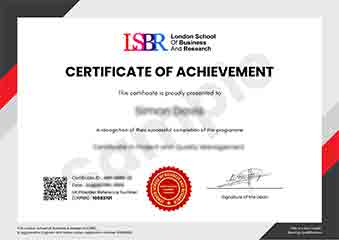
Sample Certificate
Preview the certificate you'll receive upon successful completion of this program.
Get Course Info
Receive the full course guide, pricing details, and enrolment instructions directly in your inbox.
Check your inbox!
Course details have been sent to your email.
Get Your Employer to Sponsor This Programme
Many employers offer professional development budgets. We make it easy for your company to invest in your growth with corporate invoicing and bulk enrolment options.
Email Template for Your Manager
Dear [Manager's Name],
I would like to request sponsorship for the Professional Certificate in Remote Sensing Applications in Wildlife Management programme offered by LSBR London - Executive Education.
The programme costs $149 (one-time) and can be completed in 3-4 weeks alongside my regular duties.
Key benefits to our team:
- Immediately applicable skills
- Globally recognised certificate
- Corporate invoice available
Best regards,
[Your Name]
What Our Students Say
Hear from our students about their experience with the Professional Certificate in Remote Sensing Applications in Wildlife Management at LSBR London - Executive Education.
Sophie Brown
United Kingdom"The course provided high-quality materials that were both comprehensive and up-to-date, equipping me with essential skills in using remote sensing for wildlife management. I gained practical knowledge that I can directly apply to enhance conservation efforts and habitat monitoring in my fieldwork."
Charlotte Williams
United Kingdom"This course has been instrumental in bridging the gap between theory and practical application of remote sensing in wildlife management. It has not only enhanced my technical skills but also provided me with valuable insights that are directly applicable in the field, significantly boosting my career prospects."
Klaus Mueller
Germany"The course is well-organized, providing a comprehensive overview of remote sensing applications in wildlife management that directly translates into practical skills for real-world conservation efforts. It significantly enhances my understanding and prepares me for more advanced work in the field."
Your Certification Journey
Four simple steps from enrolment to your globally recognised certificate
Enrol Online
Complete your enrolment in under 2 minutes with secure checkout
Start Learning
Get instant access to all course materials and start at your own pace
Complete Modules
Work through the curriculum with expert support available throughout
Get Certified
Receive your LSBR London certificate recognised across 180+ countries
LSBR London by the Numbers
Join a global community of professionals advancing their careers
Students Enrolled
Countries Represented
Average Rating
Career Progression